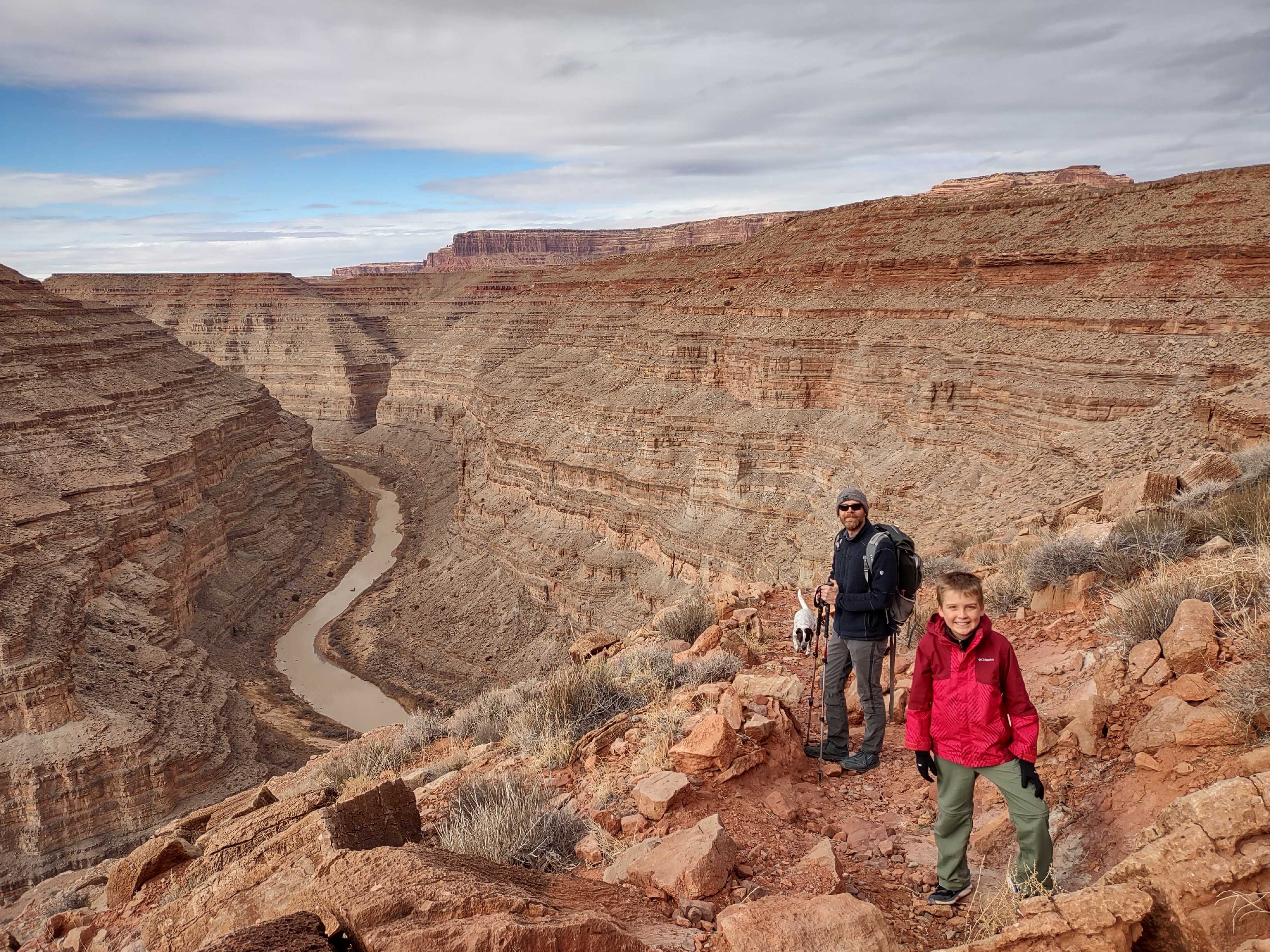
Almost exactly 11 years ago my husband and I started hiking the Honaker Trail. I say, ‘started’ because I was pregnant at the time and just didn’t have the energy to complete the full 5 mile round trip hike, which descends about 1,200 feet down to the San Juan River. (Going down wouldn’t have been a problem- it was the coming back up that I was worried about!) We hiked about 1/2- 1/3 of the trail then we turned around, and it’s hung over my head and bothered me ever since. For the past 3 years or so since I’ve felt like my son was able to do a 5+ mile hike, I’ve been suggesting the Honaker Trail whenever we’re trying to figure out where to hike on the weekends, but for one reason or another we just never made it back.

The annual Bluff International Balloon Festival was held just a couple weekends ago, and we were headed down to Bluff that Saturday for both the Art Market during the day and the Glow-in in the evening, so we decided to do a hike in between the two. Of course I took that opportunity to plead my case to my husband that it would be the perfect opportunity to do the Honaker Trail. He had been resisting for the past couple years thinking that the trail was a little too sketchy to take our son on, but he finally gave in.
After a quick stop at the Art Market at the Bluff Balloon Festival, we continued down to the Honaker trailhead, which is about 40 minutes south of Bluff and 20-25 minutes northwest of Mexican Hat, UT. The Honaker Trail is located on the very southern tip of Bears Ears National Monument, and the trailhead is accessed off Hwy 316, which is the road that leads to Goosenecks State Park. The trailhead is only about 15-20 minutes from Goosenecks, so if you’re planning to hike the Honaker Trail, be sure to stop at Goosenecks State Park- the view is spectacular! (Think Horseshoe Bend times 3!!)
We knew we were pushing it time-wise since we were starting the hike at about 2:00pm, and the Glow-in at the Bluff Balloon Festival started at 5:00pm, but we figured we’d at least be able to catch the end of the Glow-in if we didn’t take too many breaks on our hike.

Even though I’d been there before and had hiked part of the trail, as we were walking up to the rim of the canyon I couldn’t see where the trail started. I remembered that there was a large pile of rocks marking the trailhead, but as you approach the canyon rim, you really can’t see the trail at all. Once you are standing at the pile of rocks, you can see a narrow trail that begins the descent down into the canyon just to the left of the rocks.

A significant feature along the trail is a rock called, ‘Horn Point’, that juts out from the rest of the canyon wall. I think it’s pretty much a halfway point, and after you pass it the trail definitely gets a little more rough. If you’re hiking with very young children, or just looking for a shorter hike, this would be a good place to turn around.

The Honaker Trail was built in the late 1800s by Augustus Chapman Honaker and his brother Henry, with the intent to serve as a supply route for gold mining on the San Juan River. Before building the trail, Honaker and the other placer miners working on that part of the San Juan River, would lower their supplies over the rim of the canyon with ropes and would descend and ascend with ropes as well. Honaker and his crew used powder and tools to cut parts of the trail with the hope of bringing gold mining machinery down to the river.
The gold boom in San Juan County reached its peak in 1892 & 1893, but was short-lived due to the fact that the gold found in the area was extremely fine ‘flour gold’, which had eroded from the San Juan Mountains in Colorado and had been ground down to the consistency of flour as it moved downstream. If you’re familiar with the San Juan River, you know that it has one of the highest sediment loads in the Western US, so it must have been an incredibly painstaking process to try to separate the gold powder from the silt and sediment.
At its peak, there were said to be 2,000 to 3,000 placer miners working along the banks of the San Juan River, with miners both arriving and leaving daily. Historic accounts mention the difficulty of some of the larger mining companies faced with retaining workers. The January 19, 1893 Salt Lake Tribune reported that the Gable Company which employed more than 250 men, would often see employees quit after a few days of work because ‘everybody with a few dollars is out staking off claims.’
Since the San Juan River ‘Gold Rush’ was relatively short lived, the Honaker Trail was never really utilized for its original intent. Now it serves as a popular hiking trail, both from the top down for hikers, and from the bottom up for river runners on the San Juan River. It’s one of the few trails that boaters can hike out of the lower San Juan River Canyon below Mexican Hat.

Photo: University of Utah

Photo: University of Utah


In researching the history of the Honaker Trail for this post, I found several historic photos from the late 1800s and early 1900s. In the photos above you can see my photo from our hike last weekend next to a photo of the same switchback taken in 1909.

When I choose a hike, I normally prefer to do the hard part of the hike first. This works great when hiking in the mountains, but when it comes to canyon hikes it’s often the opposite. The Honaker Trail starts at about 5,150 ft and descends to about 3,960 ft at the river. Since we were hiking in the winter, the weather was cold and windy when we started, but luckily as soon as we descended below the rim of the canyon, we were out of the wind and were able to enjoy a really nice hike.
Personally, I would not want to do this hike in the summer. The only thing that would be nice about going in the summer would be getting to cool off in the river when you reach the bottom, but depending on the time of day you’re hiking, this trail could be in full sun with out any shade at all, which would be brutal in the summer.


We made it down to the San Juan River, and both my son and dog enjoyed playing on the beach for a little while. This stretch of the river has nice, wide, sandy beaches, and during peak river-running season the campsites located in this area are popular with boaters. I wish we’d had more time to spend at the river, but since we were trying to make it back to Bluff in time for the Glow-in, we couldn’t stay very long before we turned around and headed back up the trail.

I have to say, when you are at the river getting ready to start hiking back to the top, it’s a little daunting to look up at the 1,200+ ft canyon walls knowing you have to climb all the way back to the top. But with the Glow-in on our minds, we had some extra motivation!
I don’t mind heights at all, but for anyone who does, this would not be a trail that I’d recommend for them. While the hike wasn’t super steep for the most part, there were a few places where there were pretty extreme drop-offs on the side of the trail. I definitely stressed a little during those sections while watching my son hike along not seeming to be thinking about what a trip or slip could result in. I’m sure by the end of the hike he was probably sick of hearing me tell him to be careful and to take his hands out of his pockets while he was hiking, but we completed the hike safely, and that’s all that matters!


For anyone interested in geology, I’m sure this hike would be fascinating. The rocks forming the sides of the gorge are shale and limestone from the Paradox Formation and the Honaker Trail Formation, and are up to 300 million years old! Also, be on the lookout for fossilized crinoids and brachiopods along the trail!
The Honaker Trail is definitely a feat of engineering! Not only does it scale what appears at first glance to be a sheer canyon wall, but there are also a couple sections of the trail where rocks were meticulously stacked creating a smooth trail after passing through solid rock ledges. And it’s pretty amazing to know that the trail was build by hand almost 130 years ago!
We made it back to the trailhead at about 5:15pm, so the full hike took us just barely over 3 hours. If I do this hike again I’ll plan for 4 hours to have some have more time to explore down at the river. My 10 yr old son and my dog both did great on this hike, but I don’t think I would have been comfortable taking a younger child due to the extreme drop offs on the lower half of the trail. There was one place where my husband had to lift our dog up a big step on our way back up the trail, but other than that I’d say this is an extremely dog-friendly hike, especially with the water at the bottom.
It took us almost 11 years, but I’m happy to say that I can finally mark the Honaker Trail off my list! I really loved this hike, and will definitely add it to my list of hikes to take our friends and family on when they visit. (But I’ll be sure to check first to make sure they don’t have a fear of heights before we go!)
For more information or to request travel brochures, please call Utah’s Canyon Country at: 800-574-4386
Or e-mail us at: info@utahscanyoncountry.com